No products in the cart.
No More Metes and Bounds

How Idaho Got Surveyed
By Dean Worbois
Whenever I drive south from Kuna on Swan Falls Road toward the Snake River, I pass a little sign indicating a turnoff to a place called Initial Point. It’s a butte just one mile to the east on a good dirt road, but for me there always seemed to be some excuse not to run over and check it out. At last, I decided to do what I had often told myself I should do, and took that turn.
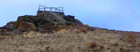
A road leads up the butte, but the steep grade is studded with sharp lava rocks, and rather than chewing up my vehicle’s tires, I opted for an easy climb to the summit. I followed the road on foot about halfway across the east side of the butte, impressed with the expanse of open country between myself and the distant mountains of the Boise Front. A rugged shortcut uphill beckoned. After a brief climb, the butte rounded onto a large flat area used for parking and, I’m sure, partying. At the southwest corner of this area, a lava outcropping rose to a point topped by a concrete platform with guardrails of pipe.
This butte may be only a hundred and twenty-five feet above the desert floor, but the flatness of the surrounding countryside makes for stunning vistas. Whether the Boise Front to the north, the Owyhee Mountains to the south, Oregon’s Mahogany Mountains to the west or the endless desert to the east, the land defines the concept of big sky. My whole life, I have explored its canyons and other features, and the grandeur of its open space.
This content is available for purchase. Please select from available options.
Purchase Only
Purchase Only

