No products in the cart.
Where Is This High Point?

Navigating South Selkirk Crest
Story and Photos by Alice Schenk
In “Highpointing the Forty-Four,” (IDAHO magazine, March 2020), Alice Schenk described several climbs in a continuing effort to reach the tallest peak in each of Idaho’s forty-four counties. In this second part of an occasional series, she describes reaching the high point in Boundary County.
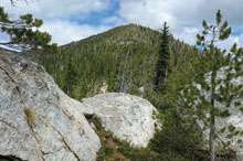
My husband Wayne and I sit below a rock face that leads to the summit of the Boundary County High Point. We can see into Canada, and my cell phone tells me Canadian rates may apply, although we’re in Idaho.We look up, wondering if we can climb the thing or if we should cut and run, come back another day. But there really is no choice. This is the most northerly county in Idaho, and returning to re-climb this ten-miler would be expensive. We will do what it takes to stay the course and finish the climb, if at all possible. Still, it’s a legitimate question. Not only does the rock face look daunting but it is late in the day. We are both spent, and we are in grizzly bear country. Wayne has already mentioned, twice, that we want to be off the mountain before dark.
Earlier, when we asked for directions to the Fisher Peak Trailhead, a young policeman said a bridge was out that crossed a creek about fifteen miles down the road. He did not know where Fisher Peak Trailhead was but told us if it was past the bridge, we would need to come back into town, cross the bridge, drive to Copeland, and cross the bridge there to get to the trailhead. We headed off, down the narrow paved Riverside Road, which became West Side Road. I spotted two bald eagles sitting in a tree alongside the road. The pavement ended twelve miles from the highway but at 14.2 miles, it was like Construction City. Less than a mile shy of our trailhead, the bridge was out. By the time we backtracked, found the trailhead, and started hiking, it was 10:30 a.m.
This content is available for purchase. Please select from available options.
Purchase Only
Purchase Only

